Those who go mushrooming don't say the places. It's the first rule of the forest, and it's also the reason why many mushroom growers don't trust an app: why should I hand over the points to a server that I don't even tell my brother-in-law?
MushScout's response is that you don't deliver those points. The map is your archive of places, and it is private by construction: there is no setting to activate, because there is no sharing to turn off.
Private means private
The coordinates of your findings do not leave the phone to other users. Your friends don't see them, they don't appear in challenges, they don't end up on a shared map — which simply doesn't exist, and isn't planned.
Even when you go out with a friend and see each other on the map in real time, what you share is where you are Now, not where you found last year. The difference is all there.
Places arise by themselves
You don't have to create anything by hand: you save a find and the place is formed around nearby points. At first it has a temporary name, and that's fine — in the woods you don't feel like writing.
Whenever you like, tap on the title and rename it: the new name applies in one fell swoop to all finds and all releases in that place. You don't have to open them one by one.
Three maps, and none that leave you stranded
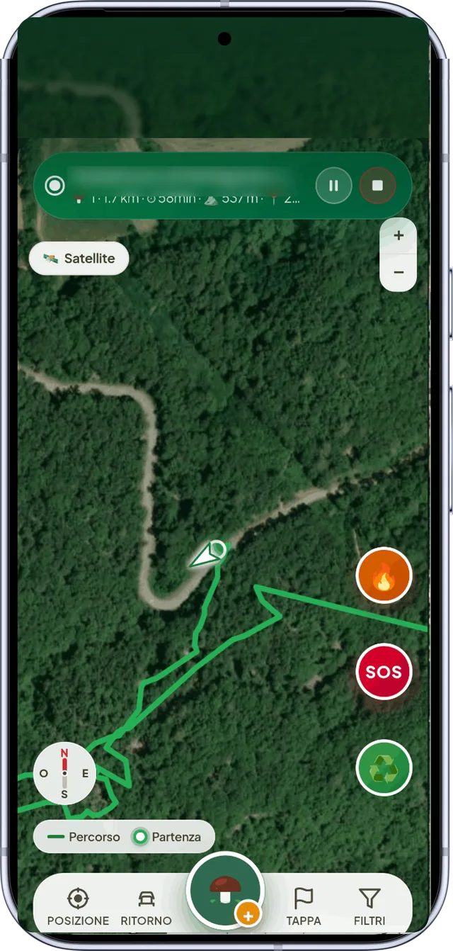
The satellite view is used to recognize the forest before leaving the house: chestnut and beech forests can be distinguished from above, and it is the quickest way to understand if it is worth trying a new area. The topography gives altitude, slope and exposure. The paths are used to decide where to enter from.
Le zone si scaricano per usarle senza campo. Nel piano gratuito è uno scaricamento, che diventano tre guardando i video: tre in tutto, non tre zone alla volta. Cancellarne una libera spazio sul telefono, non uno scaricamento; il conto lo tiene il server, quindi vale anche se cambi telefono, e l’app te lo dice prima di scaricare, non dopo. Con Premium non c’è conto. E se parti senza aver preparato niente, the app takes care of the forest around you by itself.
Il rilievo e gli impluvi · Premium
Sopra qualunque mappa, satellite compreso, si accende un velo che mostra la forma del terreno: dove il pendio è ripido, dove corrono creste e valloni, dove scende l’acqua. È la cosa che serve per decidere da dove passare, e si legge in un colpo anche da chi le curve di livello non le ha mai studiate. Per guardare un giro in tre dimensioni c’è Progetta il percorso.
La Page di ogni posto
Ogni bosco che hai segnato ha la sua Page: da lì correggi la pioggia quando il meteo ha sbagliato sul tuo versante, leggi da che parte guarda il pendio e quanto è ripido, e vedi quante uscite ci sono state qui intorno nell’ultima settimana — un numero, mai un posto di qualcun altro. Le prime due cose sono gratis; il conteggio è gratis sul primo posto. Le raccontiamo in la Page del posto.
Che bosco è · Premium
Davanti a un bosco che non conosci la prima domanda è una sola: è di latifoglie? I porcini stanno sotto faggio, castagno e quercia, i pinaroli sotto i pini, i finferli fanno tutti e due.
Dal selettore del tipo di mappa si accende uno strato che colora il bosco: verde chiaro le latifoglie, verde scuro le conifere, e dove non c’è tinta non è bosco. Il dato è Copernicus, il programma europeo di osservazione della Terra, a dieci metri di risoluzione e in tutta Europa.
Va detto anche cosa non fa: dice la foglia, non l’albero. Una faggeta e un querceto hanno lo stesso verde chiaro, e per sapere se è castagno bisogna andarci. Serve la connessione, perché è uno strato da tavolo: si guarda la sera prima, non dentro il bosco.
Scegliere un punto preciso
Quando segni un posto a mano, la mappa è a tutta Page: cerchi per nome, tocchi dove vuoi andare e trascini la mappa sotto il mirino per l’ultimo metro. Il mirino sta fermo e si muove la mappa: col pollice un punto preciso non si prende, e un posto sbagliato entra nelle previsioni e ci resta.
Si passa dal satellite alla carta topografica, perché un posto si sceglie anche per come ci si arriva. E le coordinate si incollano come sono scritte: decimali, con la virgola, con N/S/E/O, e anche in gradi, primi e secondi, come sulle carte di carta e come le manda un navigatore da montagna.
The proximity warning
As you walk, when you get close to a point where you have already found it, the app will notify you. It seems like a detail but instead it is the most used function: the mushrooms often return to the same square meters, and after a year no one remembers that specific strain.
My steps: where you have never been
You can turn on the tracks of past releases on the map. The useful part isn't the lines, it's the holes: almost everyone discovers that they always ride in the same three hundred meters, and that they've never climbed the back side.
In the free plan you see the latest five releases, with Premium all of them.
Repeat route · Premium
It's something else, and it's best not to confuse them. Choose a successful outing and the app takes you back along that road, step by step, reporting old finds as you come across them. It works even without a field.
It's useful in large, identical woods, where you can find the right route by luck: it's the difference between "I know it's from here" and exactly retracing the route of that Sunday two years ago.
Where did you find more
The hot spot map groups finds into circles, as large as the crop and with the number on it. It doesn't say where you've been: it says where you got something. Looking at it you understand in a second which forest really gives and which is just convenient to reach.
Before marking a place
A reminder that applies to everything: where you can collect, how much and on what days is decided by your region, and there are areas where collection is prohibited or reserved. The rules, region by region, are collected in this guide.
Frequently asked questions
Do other users see my posts?
No, never. There is no shared map of the finds: the coordinates do not leave your phone to other users, not even to friends or even in challenges.
Does the map work without field?
Yes. When you leave for an outing, the app keeps track of the woods around you, so the map is there even if you haven't prepared anything. If you already know where you're going, download the area first: It takes a minute and covers even the widest turns.
What is the difference between "my steps" and "repeat route"?
«My steps» is a view: it lights up the traces of past outings on the map, to see where you have already been. “Repeat route” is a guide: it takes a single exit and takes you back along that road as you walk.
Can I rename a place after creating it?
Yes, just tap on the title. The name changes together on all its findings and on all its releases.
Will the seats be lost if I change my phone?
No: they are tied to your account and return the first time you log in. And with Premium you can export everything in JSON or CSV and keep a copy of your own.